
ACR ResQLink View RLS
4.8Editor score
Return Link Service confirmation
Five-year battery life
28+ hours operational life
Multi-constellation GNSS support
Buoyant compact construction
Compare 10 locator beacon options for hiking the PCT, including PLBs, satellite communicators, SOS features, coverage, battery life, and portability.
A locator beacon can be the link between a hiker and help when the Pacific Crest Trail leaves ordinary cellular service behind. The best devices combine dependable positioning, accessible activation, long battery life, and a clear emergency path, while the most useful communicators also support check-ins, two-way messages, navigation, and location sharing.
This guide compares ten personal locator beacons and satellite communicators suited to long-distance hiking. We evaluated the supplied specifications for activation, global satellite coverage, GPS performance, messaging, tracking, waterproofing, physical size, power management, attachment options, and emergency monitoring. The list includes dedicated PLBs as well as connected devices that require an active service plan.
Each review explains where a product fits best, along with meaningful trade-offs and important setup considerations. The ACR and McMurdo models provide dedicated personal locator beacon functions, while the Garmin, ZOLEO, Motorola, and Bivy options add communication features. Product availability, service terms, registration requirements, and prices can change, so confirm current details before purchasing.
4.8Editor score

4.6Editor score
4.5Editor score
The comparison covers dedicated personal locator beacons, connected satellite messengers, and hybrid emergency devices. The key differences are activation method, satellite coverage, communication flexibility, battery life, water resistance, required subscriptions, registration, and how easily each unit can be carried throughout a multiweek PCT journey.


The ACR ResQLink View PLB425 is a dedicated personal locator beacon built around one essential job: sending an emergency alert with the hiker's GPS position to Search and Rescue authorities. It carries a 4.6 rating and stands out because it does not depend on a cellular network, a satellite subscription, or a paired phone. Once activated, it transmits a 406 MHz emergency distress signal and includes a 121.5 MHz homing signal for rescuers approaching the site.
We may earn a commission when you buy through this link, at no additional cost to you.
Its strongest PCT advantages are durability, visibility, and the ability to remain in service without a paid plan. The beacon is buoyant, lightweight, and supplied with a belt clip, lanyard, straps, and oral inflation tube clip, allowing it to be carried on a pack, belt, or flotation device. A bright LED strobe and infrared strobe provide visual signals that can help rescuers detect the beacon, particularly in darkness or dense vegetation.
The main limitation is that this is an emergency beacon rather than a general satellite communicator. It does not offer the routine check-ins, two-way messages, shared tracking, or weather functions available on the Garmin, ZOLEO, Bivy, and Motorola products. The optional 406Link subscription can support non-emergency self-tests and GPS test messages, but emergency distress operation itself does not require a subscription. That combination of dedicated emergency performance and no ongoing service requirement makes it a straightforward choice for many hikers.
Choose the PLB425 if your priority is a simple, wearable device that can call for help and keep signaling without daily charging or an airtime commitment. It is especially appropriate for solo PCT hikers, thru-hikers who want a dedicated rescue backup, and anyone who prefers a separate emergency device over a subscription-based communicator. It may be less satisfying for people who want to contact family or coordinate trip changes routinely, but for core emergency signaling it offers a mature and focused package.
The 406 MHz distress pathway is central to the PLB425's value for long trails. It sends the emergency message and GPS position directly to international Search and Rescue services, while the 121.5 MHz homing signal assists responders during the final approach. No satellite service plan is required for emergency use.
Buoyancy, a compact profile, and several attachment choices make the unit practical for creek crossings, boating sections, desert heat, and ordinary pack carry. The LED and infrared strobes add another way to remain visible if the signal brings rescuers close before the hiker can see them.
We may earn a commission when you buy through this link, at no additional cost to you.
The ACR ResQLink View RLS is the most advanced dedicated PLB in this group, combining a 4.8 rating with a reassuring Return Link Service feature. Rather than leaving the hiker uncertain after sending a distress alert, the RLS can indicate that Search and Rescue has received the signal. For a remote trail where a failed activation would be catastrophic, that confirmation adds a meaningful layer of assurance.
We may earn a commission when you buy through this link, at no additional cost to you.
The device supports GPS, Galileo GNSS, and MEOSAR compatibility, providing several positioning and rescue-system options. It has a five-year battery life and more than 28 hours of operational life after activation, which comfortably covers the length of an emergency response scenario. Built-in buoyancy and a compact, lightweight form help it tolerate wet conditions and fit into a prepared kit without becoming a burden.
Its digital display and infrared strobe improve visibility and provide clear feedback during operation. However, the RLS remains focused on distress communication rather than day-to-day connectivity. It does not substitute for the routine messaging, weather, and interactive tracking functions of the satellite communicators in this roundup. Users who expect to send casual check-ins or coordinate with a group will still need a phone, paper map, or another communications tool.
This is a compelling choice for serious long-distance hikers who want a dedicated emergency beacon and prioritize the strongest listed rating plus signal-receipt confirmation. It also suits users willing to invest in a premium device and invest a little time learning the controls before departure. The absence of a subscription makes its long-term ownership structure easier to understand, while the digital display reduces uncertainty during activation.
Return Link Service is the defining feature of this model. It confirms receipt of the emergency distress signal, helping the owner know that the alert entered the international rescue network. That feedback is particularly useful when every minute of a solo PCT journey matters.
A five-year battery life reduces the burden of maintaining a device that must remain ready for an infrequent emergency. The stated operational life of more than 28 hours is designed to support a complete response, and the buoyant enclosure provides useful protection around water.
We may earn a commission when you buy through this link, at no additional cost to you.
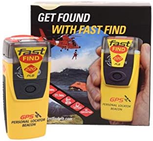
The McMurdo FastFind 220 is a dedicated personal locator beacon whose greatest strength is its uncomplicated emergency workflow. It receives a 4.5 rating and uses a simple sequence: deploy the antenna, pull the anti-tamper seal, and press the ON button. That straightforward process is valuable when a hiker is injured, cold, exhausted, or otherwise unable to manage a complex interface.
We may earn a commission when you buy through this link, at no additional cost to you.
Although this version is preprogrammed for registration with the US country code, the beacon can function internationally. Its initial emergency contact is the US Search and Rescue authority associated with the registration. Hikers outside the United States should choose the correctly programmed alternative listing for their country, and all owners should complete the legally required registration well before beginning the trail.
The trade-off is that the FastFind 220 does not improve everyday communication. It cannot send the casual updates, detailed weather, or interactive group-tracking information available from connected satellite devices. It is also less informative than the premium ACR RLS because it lacks return-link confirmation, and it does not have a visible digital screen for status details.
This model makes the most sense for hikers who want a relatively affordable, dedicated PLB without a subscription and value fast activation. It is particularly attractive for experienced users who already understand registration and emergency procedures. Anyone who wants to share location with family before an emergency or communicate throughout the day should look instead to the Garmin, ZOLEO, Bivy, or Motorola communicators.
The antenna, anti-tamper seal, and ON button create a clear sequence that can be rehearsed at home. Straightforward controls help reduce hesitation and prevent a hiker from needing a phone, menu tree, or service subscription to summon help.
Registration tells Search and Rescue who the owner is and provides emergency contacts and travel information. The included US programming is appropriate for the relevant registration route, but international hikers need the version configured for their country and must still register the individual device.
We may earn a commission when you buy through this link, at no additional cost to you.
The Garmin inReach Mini 2 is among the most practical all-around options for a PCT hiker who wants more than emergency signaling. It has a 4.6 rating and combines two-way satellite messaging, interactive SOS, location sharing, navigation aids, weather information, and Garmin ecosystem compatibility in a compact device. Unlike a dedicated PLB, it remains useful before an emergency occurs.
We may earn a commission when you buy through this link, at no additional cost to you.
TracBack routing can guide a hiker back toward the starting point of a recorded route, while the digital compass provides heading information even when stationary. MapShare and coordinates embedded in messages let family or friends follow progress. The device can pair with compatible Garmin handhelds and wearables, sync with Garmin Explore for planning, and connect to a smartphone for more detailed map work.
These capabilities come with a subscription requirement and possible jurisdictional restrictions. Two-way communication, interactive SOS, and location sharing need an active satellite service plan. Users must also understand the limits of their plan and comply with regulations where satellite communicators are restricted or prohibited. Battery performance depends on tracking and messaging settings, although the listed maximum is up to 14 days in 10-minute tracking mode.
The Mini 2 is ideal for hikers who want one device to handle emergencies, daily check-ins, weather, and some navigation. It is less attractive than a dedicated PLB for someone who specifically wants an emergency device with no service plan, but it offers much broader utility for a multiweek trail. For Garmin users, device integration further improves the experience.
Two-way messages, check-ins, shared locations, and weather information make the Mini 2 useful throughout the journey. A hiker can report conditions, coordinate with a support person, or send a normal status update without waiting for an emergency.
TracBack and the digital compass add useful backup when a trail is unclear. Garmin Explore synchronization supports offline map preparation, waypoints, courses, and route planning, although a dedicated paper map and compass remain important.
We may earn a commission when you buy through this link, at no additional cost to you.
The ZOLEO Satellite Communicator is a phone-focused satellite messaging device with a 4.4 rating. It uses a smartphone to send messages and emails through satellite, cellular, or Wi-Fi networks, selecting the lowest-cost available connection. This design makes it convenient for people who already manage trail communications through a phone and prefer a separate, lightweight hardware accessory.
We may earn a commission when you buy through this link, at no additional cost to you.
Its emergency tools include an SOS alert with GPS location through a 24/7 monitoring center, plus Medical Assist for non-emergency support. A dedicated ZOLEO SMS number and email address give contacts a direct way to reach the hiker. Check-ins, GPS coordinates, waypoint sharing, weather forecasts, and messages of up to 900 characters round out the feature set.
The major limitation is dependence on a service plan and a compatible smartphone for many functions. Users must activate the device and maintain airtime if they expect communication to work when cellular service disappears. The optional travel risk management coverage also introduces another service decision. Despite these dependencies, the IP68 rating and stated battery life of more than 200 hours offer a reassuring combination of durability and endurance.
ZOLEO is a strong fit for hikers who want everyday messaging, weather, and monitored emergency assistance in one phone-centered system. It may be less suitable for someone wanting a standalone button-activated PLB that functions independently of a phone. It also makes less sense for minimalists who prefer the small footprint of a dedicated beacon and do not need two-way correspondence.
ZOLEO uses the Iridium satellite network while also taking advantage of cellular and Wi-Fi connections when available. That network selection can reduce data use and makes the device feel less isolated from everyday communication habits.
A stated battery life of more than 200 hours provides plenty of margin for regular check-ins and weather checks. The IP68 rating also supports use in rain, dust, and wet trail conditions, although the device should still be protected according to its instructions.
We may earn a commission when you buy through this link, at no additional cost to you.
The Ocean Signal rescueME PLB1 is a remarkably compact dedicated locator beacon, particularly relevant to hikers who scrutinize every ounce of pack weight. It has a 4.6 rating, weighs four ounces, and includes a mounting clip that makes it easy to attach to a pack, life jacket, or other suitable carry point. Despite its small size, it is designed to provide a complete satellite SOS function.
We may earn a commission when you buy through this link, at no additional cost to you.
One-handed operation is a major safety advantage. A hiker can deploy and activate the device when an injury makes it difficult to use both hands or focus on a complicated control sequence. Its 66-channel GPS receiver supports positioning, while the one-candela high-intensity strobe improves visibility. The stated waterproof depth of 49 feet provides useful protection for wet crossings and maritime-adjacent sections of the trail.
The PLB1 is still an emergency-only product. It does not provide check-ins, two-way correspondence, interactive tracking, or weather forecasts. While its more than 24 hours of operational life and seven-year battery life support long-term readiness, a dedicated PLB should complement rather than replace ordinary navigation, weather awareness, and trip communication tools.
Choose the rescueME PLB1 for hikers who prioritize minimum size, simple activation, and dependable emergency signaling without a subscription. It is a particularly natural fit for fastpackers, section hikers, and anyone who wants a beacon small enough to carry every day. Those who need to talk with family or a trip leader will find the connected alternatives more versatile.
The four-ounce housing and compact mounting clip reduce both weight and space demands. This makes it easier to carry a dedicated emergency device on a fast or minimalist setup instead of leaving it behind at home.
One-handed operation helps hikers activate the PLB under stress or after an injury. The high-intensity strobe and extensive waterproof rating add visibility and physical protection in demanding outdoor conditions.
We may earn a commission when you buy through this link, at no additional cost to you.
The Flame Red Garmin inReach Mini 2 Bundle combines the core functionality of Garmin's compact satellite communicator with a useful collection of charging accessories. It includes a 10-foot USB Type A to USB Type C cable, USB charging adapters, a USB car adapter, a microfiber cleaning cloth, and a portable power bank. For a hiker who does not already own a robust charging setup, the package reduces the chance of arriving at a campsite with an unusable communicator.
We may earn a commission when you buy through this link, at no additional cost to you.
The communicator itself offers two-way messaging, interactive SOS coordinated by a 24/7 response center, weather updates, TracBack routing, location sharing, and digital compass assistance. It uses the Iridium satellite network for global coverage. Control from compatible Garmin handhelds, wearables, and mobile devices adds flexibility, while sharing coordinates or using MapShare helps friends and family follow the route.
The listed physical specifications include a body of approximately four by two inches, a weight of 3.5 ounces, MIL-STD-810 construction, and IPX7 water resistance. Battery life is listed at up to 14 days with the default ten-minute tracking interval and can extend to as much as 30 days when tracking is reduced to a 30-minute interval. That makes the device well suited to multiweek PCT stages.
This bundle is a strong choice for a hiker who wants a complete kit rather than a bare communicator. It is less compelling if the included cables, adapters, and power bank duplicate equipment already owned, and a subscription remains necessary for the major communications functions. For most users, however, the package improves readiness for a long trail without asking where to find several charging accessories.
The included portable battery charger and multiple adapters make it easier to maintain the communicator during extended periods away from wall outlets. Carry a suitable power source and verify that every cable works before the first long PCT segment.
Interactive SOS, two-way messages, shared coordinates, and live tracking provide a much broader safety net than a distress-only beacon. Flexible annual and month-to-month airtime options let users match service to their expected usage.
We may earn a commission when you buy through this link, at no additional cost to you.
The renewed Garmin inReach Mini provides access to Garmin's satellite communication platform at a lower-cost entry point. It has a 4.2 rating and offers the fundamental features many PCT hikers want: two-way text messaging, interactive SOS through a 24/7 search and rescue monitoring center, weather options, and downloadable mapping content. It is also smaller and lighter than many full-size satellite communicators.
We may earn a commission when you buy through this link, at no additional cost to you.
The free Garmin Earthmate app and compatible devices provide downloadable maps, U.S. NOAA charts, and color aerial imagery. The communicator can exchange messages with compatible Garmin handhelds and connected wearables, which helps it fit into an established Garmin equipment setup. Basic and premium weather packages may be added through the optional inReach weather forecast service.
Two cautions are important. First, this is a renewed product, so cosmetic wear, battery condition, and included accessories may differ from a new unit. Buyers should examine the listing and manufacturer information carefully. Second, an active satellite subscription is needed for two-way messaging and interactive SOS. Local regulations may also restrict satellite communication devices in certain jurisdictions.
The renewed Mini is most attractive to a Garmin-oriented hiker who values function, compactness, and a lower acquisition cost over having a factory-new unit. It is less suitable for someone who wants maximum battery longevity, a new warranty, or the expanded feature set of the Mini 2. A careful buyer can still obtain a capable safety and communications tool with realistic expectations about condition.
Earthmate support gives the communicator access to downloadable maps, NOAA charts, and aerial imagery for offline use. These resources improve route awareness, but they do not replace a paper map, compass, and sound judgment about difficult terrain.
Condition can differ across renewed inventory. Review the current listing, confirm the battery and controls, test charging and messaging, and avoid relying on an uncertain accessory package. Registration and service activation remain the buyer's responsibility.
We may earn a commission when you buy through this link, at no additional cost to you.
The Motorola Defy Satellite Link is an entry-level approach to satellite communication for Android and iPhone users. It has the lowest listed rating in the group at 3.7, but it addresses a clear need with a rugged handheld device that supports two-way satellite messaging, location check-ins, and emergency SOS assistance. It operates with iOS 14 and Android 10 or later.
We may earn a commission when you buy through this link, at no additional cost to you.
A dedicated check-in control allows the hiker to send coordinates or a message to contacts without waiting for a conventional connection. The SOS feature can be triggered without cellular service, and every service plan includes unlimited SOS according to the supplied information. This makes it useful for basic check-ins and emergencies, although it does not offer the advanced navigation, weather depth, tracking, and group features found on Garmin, Bivy, and ZOLEO devices.
Users must purchase a service plan, and actual service behavior should be confirmed for the intended route and jurisdiction. The listed rating also suggests that buyers should examine recent customer feedback for details about setup and real-world use. The device should not be assumed to duplicate the route planning, interactive tracking, or group coordination offered by more capable communicators.
The Defy Satellite Link is a practical choice for a hiker who primarily wants check-ins and emergency support without paying for a premium full-feature unit. It may be particularly useful as a simple supplementary device for someone already carrying a detailed navigation setup. For extensive messaging, live tracking, group collaboration, or a standalone PLB experience, one of the higher-rated alternatives is a better fit.
The check-in button simplifies the most common off-grid communication task. Coordinates or short messages can be sent through the service, allowing support contacts to know where the hiker is without requiring a full satellite tracking workflow.
The device is designed to use satellite SOS assistance when ordinary cellular connections are unavailable. Its iOS and Android compatibility broadens phone compatibility, but the phone itself remains an important part of the user experience.
We may earn a commission when you buy through this link, at no additional cost to you.
The ACR Bivy Stick is a satellite communicator, GPS tracker, and SOS device aimed at hikers, guides, outdoor teams, and families. Its 3.8 rating places it near the bottom of this group, but its feature set is unusually broad. Global Iridium coverage supports two-way SMS, email, weather updates, GPS tracking, offline maps, location sharing, and emergency activation.
We may earn a commission when you buy through this link, at no additional cost to you.
The strongest differentiator is GroupTrack, which can share locations with up to 12 people and display a group through the Bivy Stick, mobile app, or web browser. A live map can show exact coordinates and a breadcrumb trail, making the device useful for families, organized trail crews, and friends traveling at different speeds. The built-in GPS also tracks pace, mileage, and altitude.
After activation, each unit receives a dedicated SMS number and email address. Emergency alerts can be sent from the device button or Bivy app to 24/7 monitoring by Global Rescue. The app supports offline global maps and a large library of curated adventures. As with other connected products, a plan is required, and the hiker must keep the chosen service current.
The Bivy Stick is a good match for groups and hikers who want active location sharing rather than emergency-only signaling. It also provides a broader travel platform through the app. Those seeking the highest customer rating, the simplest dedicated PLB, or the strongest return-link confirmation may prefer an ACR ResQLink model instead. Even so, the Bivy Stick remains a capable choice when group tracking and offline maps lead the requirements list.
GroupTrack can involve as many as 12 people, and live breadcrumbs make it easier to see how a party is distributed. That visibility can support family trips, reunions, and teams whose members move at different speeds.
Built-in GPS and downloadable global maps allow navigation without cellular service. The app adds pace, mileage, altitude, route details, weather, and curated adventures, although users should still carry conventional navigation tools.
We may earn a commission when you buy through this link, at no additional cost to you.
The right PCT locator beacon depends on how much communication you want, whether you value a subscription-free dedicated PLB, and how the device will be carried. The following factors cover emergency reliability, coverage, navigation, battery life, durability, registration, and practical long-distance use.
A dedicated personal locator beacon is designed primarily to send an SOS and position to rescuers. ACR ResQLink and McMurdo models, plus the Ocean Signal PLB1, generally provide the most focused emergency experience and do not require an ongoing satellite plan for core distress operation. A satellite communicator adds two-way messages, check-ins, weather, and possibly live tracking, but normally requires active airtime. Choose a PLB for simplicity and independence, or a communicator when routine contact is part of your trip plan.
Global satellite coverage should be considered alongside the service networks and rescue systems used by each device. The dedicated ACR and McMurdo beacons transmit through international rescue satellite infrastructure, while Garmin, ZOLEO, Bivy Stick, and Motorola offerings rely on satellite communication services and may use Iridium networks. GPS, Galileo GNSS, and MEOSAR compatibility add positioning options on selected models. Confirm that the service and registration route work for the countries crossed during your PCT journey.
A beacon can transmit a distress alert directly to Search and Rescue or route it through a monitoring center, depending on the product. The ACR PLB425 sends its emergency signal directly to Search and Rescue authorities, while the RLS adds return-link confirmation that the signal was received. Connected devices such as Garmin, ZOLEO, Bivy Stick, and Motorola provide interactive SOS and monitoring. This difference matters because a hiker gains useful confidence when a device confirms that help received the alert.
Long PCT stages demand dependable power, but the best battery specification depends on the device type. Dedicated PLBs advertise multi-year standby lives and more than a day of operational time after activation. Connected communicators must power tracking, messaging, and weather functions, making settings important. The Garmin inReach Mini 2 lists up to 14 days at a ten-minute tracking interval, while ZOLEO lists more than 200 hours. Carry a suitable charging cable or power bank even when the standby figure seems generous.
A device that is too bulky may stay at home, so weight and attachment options deserve careful attention. The Ocean Signal PLB1 weighs four ounces, while the Garmin Mini 2 is listed at 3.5 ounces. Larger ACR and McMurdo units still remain compact, and the PLB425 includes a belt clip, lanyard, straps, and flotation-related clip. For a long trail, consider where the device will live: a belt, shoulder strap, pack lid, life jacket, or the top of the main compartment where it remains easy to reach.
The PCT crosses rivers, encounters rain, and exposes gear to dust, mud, abrasion, and wide temperature changes. Several options are explicitly buoyant, while the Ocean Signal PLB1 is waterproof to 49 feet and ZOLEO carries an IP68 rating. Garmin's Mini 2 is listed with IPX7 water resistance and MIL-STD-810 construction. Ratings describe controlled laboratory conditions rather than every real-world scenario, so use a protective case and dry the device after severe wet conditions according to the manufacturer's guidance.
Owning the device is not the final step. PLBs must generally be registered, sometimes according to the country code programmed into the unit. The McMurdo FastFind 220 in this list is programmed for US registration, while international users need the appropriate alternative listing and registration route. Connected communicators require service activation, current airtime, and compliance with local restrictions. Before leaving, activate the service, send test messages, complete SOS instructions, and confirm that emergency contacts know how to respond.
A locator beacon is a safety and communications tool, not automatically a complete navigation system. Garmin devices add TracBack, digital compass functions, Earthmate mapping, and Garmin device integration, while the Bivy Stick provides offline maps, live breadcrumbs, and GroupTrack for up to 12 people. ZOLEO supports waypoints and weather forecasts. Even with these features, carry a paper map, compass, route plan, and backup power. Extra navigation capabilities are most useful when they complement rather than replace sound preparation.
Before departure, read the complete instructions for the exact model, register the PLB where required, activate any satellite service, and configure emergency contacts. Charge the device fully, learn the activation sequence, and practice it in a safe location. Download the appropriate maps, establish a tracking or check-in routine, and send test messages that confirm both the device and the receiving contacts are working.
Carry the beacon where it is accessible and protected from impact or prolonged heat. Use the supplied clips, straps, lanyard, or mounting system, and inspect the attachment before each substantial section. For connected products, follow the manufacturer's guidance for battery conservation, confirm that the airtime plan remains active, and avoid using unfamiliar controls during an emergency. Recheck the local forecast, route conditions, and registration details whenever practical.
Use a dedicated PLB only for grave and imminent danger, as false alerts can divert rescue resources. If a device is wet, dirty, or damaged, power it down when appropriate, clean and dry it according to the manual, inspect the antenna and contacts, and test it again. Know the expected battery life after activation, carry backup navigation, and replace or service a unit if its physical condition or battery performance raises concern.
It is not universally required, but it is a valuable safety tool for long stretches without cellular service. Requirements vary by land-management agency, route, season, and individual circumstances. Check current PCT and managing-agency guidance, then choose a device that matches your risk tolerance and trip length.
A PLB focuses on sending an emergency distress alert and GPS position to rescuers. A satellite communicator also supports routine two-way messages, check-ins, weather, and sometimes live tracking. PLBs often work without a subscription for core emergency alerts, while communicators normally require active satellite service.
Yes. Dedicated PLBs and satellite communicators use satellite systems specifically for signaling away from cellular networks. Coverage and service quality can vary by terrain, device, and jurisdiction, so users should test service before departure and still carry paper navigation and backup plans.
A phone remains useful for offline maps, weather research, photos, and application-based controls, but a dedicated PLB should not depend on a powered phone for its basic SOS function. Communicators such as ZOLEO, Motorola, and Bivy use phone-based workflows to varying degrees, so account for that dependency when choosing.
There is no universal interval, but regular check-ins improve awareness for support contacts and can reveal changing conditions. Choose a schedule that matches your route, device battery, and plan. If you rely on tracking, select an interval that balances location updates with power consumption.
Yes, registration is required by law in most countries and helps rescuers identify the owner and relevant contacts. Registration details must be accurate and kept current. The McMurdo FastFind 220 listing is programmed for US registration, so international hikers need the correct country version and registration process.
No. GPS features, offline maps, TracBack, and digital compasses are useful backups, but electronics can run out of power, lose a signal, become damaged, or be misused. Every serious PCT kit should also include a current paper map, compass, route notes, and the knowledge to use them.
Avoid unintentionally triggering a real rescue response. Use the manufacturer's self-test functions or customer support process, and do not pull a protected distress activation unless there is a genuine emergency. Review the manual, distinguish test mode from emergency mode, and make sure accidental activation cannot occur inside the pack.
The ACR ResQLink View PLB425 is the strongest all-around dedicated choice for most hikers, offering direct rescue signaling, GPS positioning, no subscription requirement, buoyancy, and useful visual strobes. The ACR ResQLink View RLS is the premium alternative when return-link confirmation and extended operational readiness justify the added investment, while the McMurdo FastFind 220 provides a straightforward, budget-conscious emergency beacon with simple activation.
Hikers who want regular contact should focus on the Garmin inReach Mini 2, ZOLEO, Bivy Stick, or Motorola Defy Satellite Link. Garmin leads in navigation and ecosystem integration, ZOLEO emphasizes phone-centered messaging and battery endurance, Bivy Stick supports group location sharing, and Motorola offers an entry-level check-in and SOS option. Prioritize the functions you will actually use, then confirm service, registration, battery strategy, and physical attachment before departure.
Finally, check current product details, service requirements, accessory availability, and prices immediately before purchasing. Conditions, regulations, and plans can change, and a device that seems ideal on paper should also be registered, charged, tested, and carried in a way that makes it genuinely useful on the PCT.